BUOYS & MOORINGS
SHIP SURVEYS
GLIDERS
SHIPS OF OPPORTUNITY
CORAL REEF MONITORING


MONITORING

Understanding the exposure of the nation’s living marine resources such as shellfish and corals to changing ocean chemistry is a primary goal for the NOAA OAP. Repeat hydrographic surveys, ship-based surface observations, and time series stations (mooring and ship-based) in the Atlantic, Pacific, and Indian Oceans have allowed us to begin to understand the long-term changes in carbonate chemistry in response to ocean acidification.


What do we measure to assess ocean acidification? 

The Big Four OA Parameters

pH

When the ocean absorbs carbon dioxide, chemical reactions create hydrogen ions that act like free agents, able to react with other compounds. Two ways we track ocean acidification are through pH and total alkalinity (TA). pH is a measure of how many free hydrogen ions are in the seawater. The more carbon dioxide in the ocean, the more these free agents are created, causing lower pH (more acidic).

pCO2

The partial pressure of CO2 (pCO2) tells us how much carbon dioxide is in seawater. This information helps us understand ocean carbonate chemistry and biological productivity in the region. pCO2 increases when the ocean absorbs more CO2 from the atmosphere with elevated emissions.

TA

Alkalinity is the ocean’s buffering system against increasing acidity. Total alkalinity is a measure of the concentration of buffering molecules like carbonate and bicarbonate in the seawater that can neutralize acid. 

DIC

Dissolved inorganic carbon (DIC) tells us how much non-biological carbon is in seawater. Inorganic carbon comes in three main forms that we measure for DIC: carbon dioxide (CO2), bicarbonate (HCO3-), and carbonate (CO32-). Understanding DIC can help us determine the balance of carbonate forms in the ocean and the likelihood of ocean acidification.

Buoys & Moorings

There are currently 19 OAP-supported buoys in coastal, open-ocean and coral reef waters which contribute to NOAA's Ocean Acidification Monitoring Program, with other deployments planned.

Currently, there are two types of floating devices which instruments can be added in order to measure various ocean characteristics - buoys and wave gliders. Buoys are moored, allowing them to remain stationary and for scientists to get measurements from the same place over time. The time series created from these measurements are key to understanding how ocean chemistry is changing over time. There are also buoys moored in the open-ocean and near coral reef ecosystems to monitor the changes in the carbonate chemistry in these ecosystems. The MAP CO2 sensors on these buoys measure pCO2 every three hours.

Access our buoy data


Ship surveys

Research cruises are a way to collect information about a certain ecosystem or area of interest.

For decades, scientists have learned about physical, chemical and biological properties of the ocean and coasts by observations made at sea. Measurements taken during research cruises can be used to validate data taken by autonomous instruments. One instrument often used on research cruises is a conductivity, temperature, and depth sensor (CTD), which measures the physical state of the water (temperature, salinity, and depth). The sensor often goes in the water on a rosette, which also carries niskin bottles used to collect water samples from various depths in the water column. Numerous chemical and biological properties can be measured from water collected in niskin bottles.


Ships of Opportunity

Ships of Opportunity (SOPs) or Volunteer Observing Ships (VOSs) are vessels at sea for other reasons than ocean acidification studies, such as commercial cargo ships or ferries.

The owners of these vessels allow scientific instrumentation that measures ocean acidification (OA) parameters to be installed and collect data while the ship is underway. This allows data on ocean chemistry to be collected in many remote areas of the world's ocean, such as high latitude waters, long distances from land (e.g. mid-basin waters), and places not easily accessible by research cruises. These partnerships have greatly increased the spatial coverage of OA monitoring world-wide. To learn more, check out the Ships of Opportunity programs established by the NOAA Pacific Marine Environmental Laboratory (PMEL) and the NOAA Atlantic Oceanographic Marine Laboratory (AOML).


Wave Gliders

Scientists at the NOAA Pacific Marine Environmental Laboratory (PMEL) are working with engineers at Liquid Robotics, Inc. to optimize a Carbon Wave Glider.

This instrument (pictured above) can be driven via satellite from land. Carbon Wave Gliders can be outfitted with pCO2, pH, oxygen, temperature and salinity sensors, and the glider’s equipment takes measurements as it moves through the water. The glider’s motion is driven by wave energy, and its sensors are powered through solar cells and batteries, when needed.


CORAL REEF MONITORING

NOAA’s Coral Reef Conservation Program (CRCP) in partnership with OAP is engaged in a coordinated and targeted series of field observations, moorings and ecological monitoring efforts in coral reef ecosystems.

These efforts are designed to document the dynamics of ocean acidification (OA) in coral reef systems and track the status and trends in ecosystem response. This effort serves as a subset of a broader CRCP initiative referred to as the National Coral Reef Monitoring Plan, which was established to support conservation of the Nation’s coral reef ecosystems. The OAP contributes to this plan through overseeing and coordinating carbonate chemistry monitoring. This monitoring includes a broadly distributed spatial water sampling campaign complemented by a more limited set of moored instruments deployed at a small subset of representative sites in both the Atlantic/Caribbean and Pacific regions. Coral reef carbonate chemistry monitoring is implemented by researchers at the NOAA Atlantic Oceanographic & Meteorological Laboratory (AOML) and NOAA's PIFSC Coral Reef Ecosystems Division.


LEARN MORE ABOUT HOW WE MEASURE CORAL REEF CHANGE


OAP SUPPORTED MONITORING PROJECTS

A Sentinel for Change: Secrets along the seafloor in Olympic Coast

A Sentinel for Change: Secrets along the seafloor in Olympic Coast

NOAA Ocean Acidification Program

Author: Jennifer Mintz/Thursday, August 24, 2017/Categories: ocean acidification, OA monitoring

Rate this article:
No rating

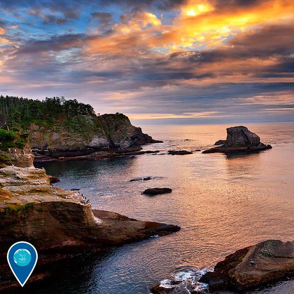
Whether you arrive on the Olympic Peninsula by land, sea, or air, you sense its remote, rugged and vast environment immediately. The Olympic Coast is home to productive waters which sustain thriving marine and coastal communities that have long supported the region’s tribal peoples. Ocean waters quickly deepen just offshore, boasting canyons which extend almost a mile below the surface – and have yet to be fully explored.

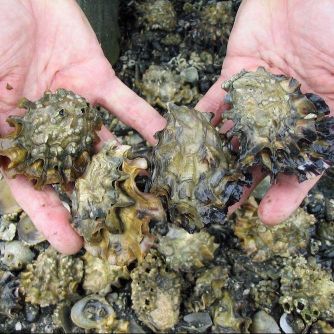
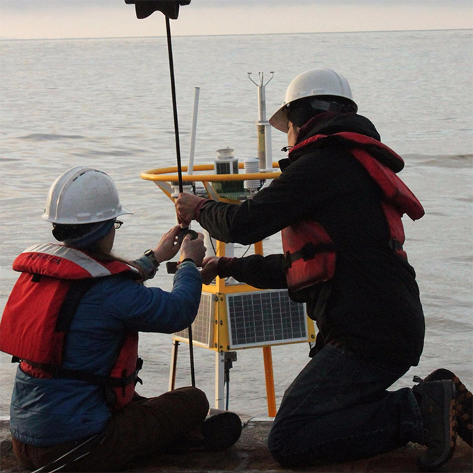
Scientists aboard the R/V Nautilus are exploring these wonders in the Olympic Coast National Marine Sanctuary from August 18th to September 4th, 2017 by deploying nets and unmanned vehicles to get a peek at life under the sea. The sea floor itself also holds clues to a change this region is particularly vulnerable to – ocean acidification. During spring and summer along the Olympic Coast, deep, cold waters rise from the canyons and other offshore areas bringing excess carbon dioxide produced by human activities to coastal waters.  Culturally, ecologically, and commercially important marine species, like Dungeness crab, and the food-webs they are a part of may be challenged by these waters high in carbon dioxide. The unmanned vehicles operated by the R/V Nautilus team provide a rare opportunity to sample layers of the seafloor. Their observations will give insights into the environment organisms experienced in the past and how that compares to the conditions found along the Olympic Coast today.

Olympic Coast ocean waters are projected to acidify rapidly in the future, crossing chemical thresholds known to affect the regions’ marine species. Putting these projected changes into a historical context is key to getting a sense of how this marine ecosystem will respond to changes in ocean chemistry. Were species affected with past changes? Did they persist and adapt? Looking back in time provides a foundation to better understand how this marine ecosystem and the communities that are tied to it could adapt.

The Olympic Coast is a sentinel of change for ocean acidification. In this special place, researchers are working year-round to understand the physical, chemical and biological impacts of ocean acidification. Managers are using this understanding to inform and enhance efforts to sustain and utilize resources vital to the communities that call this place home. Collaborative research and monitoring efforts are being integrated with education and outreach to define adaptive management tools that Olympic Coast communities can use to face ocean acidification head-on

You can see what secrets scientists onboard the R/V Nautilus uncover live by tuning into the Nautilus Live website!

Learn more about the Olympic Coast National Marine Sanctuary here!


Print

Number of views (6252)/Comments (0)

Please login or register to post comments.

x