Improving data assimilation algorithms for faster execution, higher resolution and application coupling for U.S. West and East coast ocean forecast systems
Why we care
Estimates and forecasts of ocean conditions support critical needs such as navigation, search and rescue, environmental hazard response, fisheries and public health. Multiple existing analysis and forecast systems within U.S. Integrated Ocean Observing System (IOOS) regional associations as well as NOAA’s West Coast Operational Forecast System (WCOFS) rely on the Regional Ocean Modeling System (ROMS) and its supporting data assimilation (DA) tools. Advanced data assimilation (DA) is computationally expensive, often requiring 50 times the compute effort of a single non-data-assimilative forecast. Given the computational resources typically available for near-real-time systems (NRT), this expense can limit the resolution of DA models. This project aims to improve the performance of these tools for operational applications for a variety of users.
What we are doing
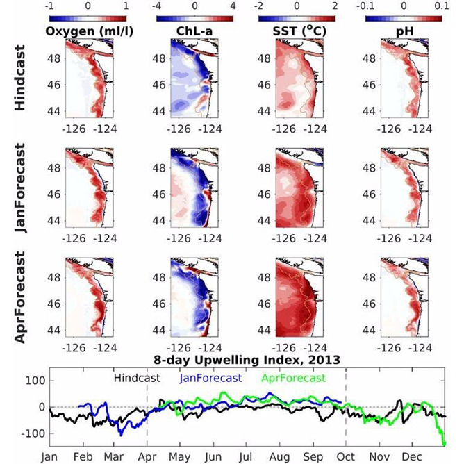
Fundamental to the skill of regional ocean analysis and forecasting is high spatial resolution and advanced data assimilation. It is important to report at resolutions useful to informing maritime operations and transports of pollutants, larvae and algal blooms. Data assimilation brings the observed and modeled ocean state into better agreement – this makes applications like weather and ocean condition predictions the best possible to launch a forecast.
This project will accomplish the following:
- Achieve faster data acquisition, enabling the practicality of higher resolution analyses and forecasts;
- Expand capabilities for better utilizing the information of high-resolution observations used in existing operational systems;
- Create an infrastructure to run coupled ROMS-biogeochemical models that exploit the enhanced ocean physics state estimates delivered by operational systems;
- Develop tools to facilitate hands-on user training in running advanced data acquisition systems and enable the user community to experiment with system performance, ecosystem forecasting, coupling, and observing system design;
- Solicit user and community priorities and requirements for the next generation of analysis and near real-time forecasts.
Benefits of our work
This project is directed at enabling NOAA Center for Operational Oceanographic Products and Services (CO-OPS) and IOOS regional associations to deliver more accurate and more highly resolved forecasts to key users concerned with fisheries, ecosystem health, navigation, maritime safety, response to marine environmental hazards, and a sustainable ocean economy. The project will deliver ROMS data assimilative forecasts at higher resolution than at present and reduce computational footprint of existing operational systems to improve performance. The work will also produce a biogeochemical model coupled to West Coast Operational Forecast System output and run operationally within IOOS regional associations.
Indirect project benefits of higher resolution and accuracy will cascade to existing downstream products that use operational analysis forecast systems, such as for HAB prediction and fisheries management.
This work is funded in partnership with the U.S. Integrated Ocean Observing System (IOOS).
Read the IOOS webstory
Investigators
John Wilkin, Rutgers University
Hernan Arango, Rutgers University
Andrew Moore, University of California, Santa Cruz
Christopher Edwards, University of California, Santa Cruz
Partners
NOAA Coastal Survey Development Laboratory (CSDL)
Mid-Atlantic Region Association Coastal Ocean Observing System (MARACOOS)
Central and Northern California Association Coastal Ocean Observing System (CeNCOOS)
Southern California Association Coastal Ocean Observing System (SCCOOS)
Northwest Association of Networked Ocean Observing System (NANOOS)